
The Science Behind Tropical Storm Debby’s Slow Movement
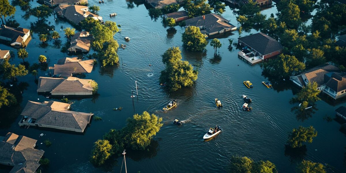
Tropical Storm Debby crept across the Southeast in early August 2024, inundating parts of Florida, Georgia, and the Carolinas with relentless rainfall. Cities and farmlands were deluged, with some areas receiving over a foot of rain by August 7. The storm’s slow pace allowed for prolonged heavy rain, exacerbating flooding risks across the region.
Mathew Barlow, a climate scientist at UMass Lowell, sheds light on why storms like Debby accumulate so much moisture and what factors contribute to their sluggish progress. He explains that hurricanes are influenced by surrounding weather systems, such as other storms and the Bermuda High over the Atlantic Ocean.
In Debby’s case, a high-pressure system over the western U.S. impeded its movement, while the Bermuda High was too distant to affect its trajectory. This scenario mirrors the stalling of Hurricane Harvey in 2017, which resulted in over 50 inches of rain in Texas due to similar high-pressure blockages.
When storms move slowly, they have more time to release rain over the same area, significantly increasing flood risks. Debby’s prolonged presence has led to severe flooding in the Southeast, highlighting the dangers of slow-moving tropical systems.
Why Debby Is Carrying So Much Rain
The Atlantic Ocean and Gulf of Mexico have experienced unusually high surface temperatures over the past year. This vast area of warm sea surface temperatures leads to increased evaporation. Consequently, the atmosphere, also warmer than average, holds more moisture, contributing to the heavy rainfall.
This phenomenon creates a perfect environment for tropical storms to produce intense rainfall. Debby is traversing a region saturated with exceptional moisture from the Gulf to the East Coast, drawing in this moisture from all directions and resulting in substantial rainfall.
Furthermore, the storm’s proximity to the coast allows it to maintain its strength. The abundant moisture over the ocean acts as fuel, preventing the storm from weakening quickly. If Debby had moved further inland, it would have lost intensity more rapidly.
As Debby continues northward, the warm, moist air extends up the East Coast, increasing the likelihood of heavy rain and flooding in the Mid-Atlantic and Northeast. Interaction with other weather systems will further amplify these effects.
The Impact of Climate Change on Tropical Cyclones
Human-induced climate change is driving up ocean and atmospheric temperatures. This warming stems mainly from fossil fuel combustion, which releases greenhouse gases that trap heat near the Earth’s surface. The resulting warmer conditions contribute to higher rainfall rates and more rapidly intensifying storms.
Research suggests that hurricanes affecting the U.S. are slowing in their forward movement, potentially linked to climate change. However, the exact nature of this connection remains under investigation.
Without a swift reduction in fossil fuel emissions, these intense storms and their accompanying rainfall will likely continue to increase. The positive news is that we possess the knowledge and means to cut emissions, and efforts to do so are gaining momentum globally.
Key aspects of climate change’s influence include:
- Increased sea surface temperatures leading to more evaporation
- Warmer air holding more moisture, resulting in heavier rainfall
- Potential slowing of hurricane forward motion, increasing flood risks
Future Outlook for the Northeast
Tropical Storm Debby is projected to persist over the Southern U.S. or just offshore for several days, posing a high risk of excessive rainfall and potential catastrophic flooding, particularly in the Carolinas. The storm’s slow movement heightens these dangers.
Significant rainfall is also expected in parts of the mid-Atlantic and Northeast, with areas from Philadelphia to New York City already under flood warnings. A frontal boundary is contributing to the buildup of tropical moisture in these regions.
As Debby moves further north and interacts with additional weather systems, it is expected to accelerate and head toward Atlantic Canada. However, it will leave behind extensive flood damage across vast areas.
Residents in the storm’s path should stay vigilant and prepared for potential flooding. Authorities are working to mitigate the impact, but the scale of the challenge underscores the need for effective climate action and disaster preparedness.
Adeline_Quantum6
Great article, but I wish there were more on what local governments are doing to mitigate these risks.
mason_empress
The connection to climate change makes sense. We really need to act on reducing emissions.
JaneCelestial
OMG, this sounds like something out of a disaster movie! 😱
Sophie
Interesting read, but how can we prepare better for such events?
paisley
Why didn’t the Bermuda High affect Debby’s movement this time?
Felix
Does this mean we should expect more slow-moving storms in the future?
zoe
Wow, over a foot of rain in just a few days? That’s insane! 🌧️
Max_Mystic1
Thank you for the detailed explanation, Mathew! It’s alarming to see how climate change is influencing these storms.